TELECOM,GAS & OIL SECTOR
Telecom
Network Engineer Implementation
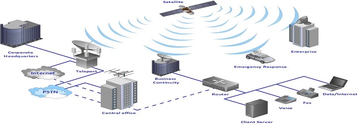
Network Engineer is a scalable, GIS-based network management system that helps you efficiently plan, design, maintain and document ongoing changes to your inside and outside plant facilities. So you can streamline work order management and accurately track all of your moving pieces, from cabling to equipment. VS is involved in carrying out the FTTH Role out (Design and Planning of FTTX Network) using the Network Engineer.
Network Engineer is Built on the Esri® ArcGIS® platform, Network Engineer is built to handle any multivendor, multi technology infrastructure. The sophisticated geodatabase houses all physical network inventory and keeps track of both planned and as-built networks. It overlays network layouts on top of the land base so planners can see equipment, demographics, and customer information in a single view.
The Core team at VS does bring lot of this experience with them, as previously they were involved implementing of the same solution at various international and national client sites. They have got the experience of OSP and ISP data conversion, Migration, designing and planning experience with them.
OSP DATA CONVERSION & MIGRATION
- System Configuration
- Database Creation and Configuration : Making the Client Data compatible to Target System.
- Defining Classes& Categories : Defining additional classes which are specific to the client to map the data into the target system.
- Attribute value & Domain Definitions : Maintain integrity of Client Data model in the Target System.
- Setting up Rules (Generic or Client Specific) : These are additional to the target system to maintain the integrity of clients legacy data.
- Symbology : To visualize the data in GIS system and on the field.
- Labeling : To identify the features and the data linked to the feature.
- Model Building : Creation of Model of Network elements based on the data available in the client system to have its real representation in the target system.
- Model mapping : Mapping the network elements available with client to the models created in the target system.
- Field Mapping : Mapping of Clients System Fields to the Target System fields.
- Work Order life cycle : To map the actual work order life cycle followed by the client in real environment.
- Creation of users and defining their roles : To have a control on the data for different users based on the type of their activity.
- Template creation for plotting of layouts : To have the printouts which can be taken to the field survey/updates.
- Conversion from different Sources
- With our past experience of handling different Telecom Projects we know that the telecom data exists in many different formats like AutoCAD files, Micro-station files, Pdf's, Xls or may be some database.To bring this data on a single platform we require its conversion in the target platform format.
- Migration of Data into Target Platform
- The converted data is then migrated into the target system keeping all the rules and database requirements into considerations.
- Connectivity( Simple & Ring Connectivity)
- Connectivity brings life to the telecom data. The network is said live when its elements are connected to each other and a trace can run on it either Upstream or Downstream. This connectivity is created between Trans-media to trans-media, Equipment to Trans-media, vice versa.
- Ring Formation
- Ring Network is a circular pattern of fiber optic cables typically localized to transmit data and information at very high speeds over a short distance within a specific region.
ISP Conversion & CREATION
- DETAIL VIEW CREATION
- Manhole Layout Views Duct and trans-media Utilization shown on Manhole walls.
- Span Cross section view This View shows Duct Space Utilization in trench.
- CDF View (Central Office) ISP of CDF shows Rack, Chassis, Slot, Plug-in.
FTTx Planning & Design

The telecommunications has matured to offer network convergence and enable the revolution of consumer media device interaction. The ageing copper access infrastructure in residential and business locations is unable to meet the demand of increase in bandwidth for several applications. These demands can only be met by the deeper penetration of optical fiber in Access network and increasing deployment of Fiber to the Home (FTTH). As a result FTTH is the fast growing global broadband technology with significant deployments World-Wide.
The development of single mode optical fiber, with its nearly unlimited bandwidth has unlocked the possibilities for massive deployment of long Haul and access fiber networks, resulting in three important changes.
- Huge Capacity increase.
- Substantial cost reductions in equipment, operations and maintenance.
- Significantly improved quality of service.
- Unrestricted-Bandwidth, Distance and Coverage , Upgrade.
Online Work Order Implementation
For any network, build, removal, or rearrangement, it provides time and material costing, bills of material, work task timing, sequencing and assignment, a way to record field notes, rights-of-way, acceptance criteria, approvals at various project stages, and as-built details of the completed work. VS Geospatial Technologies does have ample experience of implementing the work order online where Client does not have to do any work like conversion or migration.
- Planning Work Order.
- Release to Construction.
- Design Complete Work Order.
- Design Work Order.
Oil & Gas

Integrated Pipeline Map
The integrated pipeline map was created based on the source of inputs, type of inputs and the requirement gathered from the end user and the Client. VS Geospatial Technology was involved in this project from Carrying out the Work shop to gather the requirements and to freeze the data model of the target GIS System. Plotting was also part of the scope. We know that the pipelines network originates from wellhead through the tough terrain terminating at refinery and/or sea port.
Creation of 2D Alignment sheets for Oil Pipeline
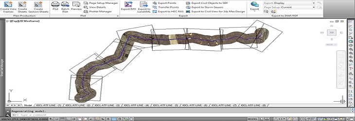
This project required survey of whole pipeline and creation of complete pipeline alignment based on the survey inputs. We also created a 3D visualization (Fly-through) for whole pipeline. The platform used for creation of alignment sheets was Autocad Civil 3d.
- Creation of Template in AutoCAD for alignment sheets.
- Conversion of Survey inputs in AutoCAD.
- Creation of surface (DEM).
- Creation of Alignments between IP Points.