Portfolio

Services We Offer

Services Sectors Description Of Services
GIS Geospatial Land base Creation using Satellite Imagery ( Ikonos, Geoeye, Google), Maps
Remote Sensing, like Ortho-Rectification, Land use & Land Cover Classification using Digitization or Classification Techniques
GIS Mapping like Digitization, Drafting using Different sources like using images, Web Application, Links, Data Dictionary
DEM, DTM Data Creation
LIDAR Data Classification
Utility Sectors Telecom
Power & Water
OIL & Gas
Civil
Conversion and Migration of Telecom Data into Network Engineer or any other System like Small World, Spatial Net
OSP( Out Side Plan) & ISP ( Inside Plant) Conversion
Creation of Details Views like ( Manhole Layout View, Span Cross Section views, Inside Plan View ) etc
Planning and Designing of FTTX Network based on inputs from the Client
Work Order Implementation ( Online as well as Offline)
Conversion and Migration of Power Network Data, Water, Sewage Network Data into GIS System
Creation of Network Data using various international accepted data models
Profile and Alignment Sheets ( 2D or 3D Alignment Sheets) using Survey Data, Legacy Sources available with Client
Conversion & Migration into target System based on the Client Required and System Data Model
Creation of Integrated System/Map, Plotting
Creation of Floor Plans/ Layout Plans
Creation of Polylining to Know the Square Footages Using IFMA & BOMA Standards
Creation/ Conversion of Civil Data to carry the Space management Analysis
Project Consultancy All Utilities Technical Documentation
Effort Estimation
Rule Base Creation, FDS, DMS , Conversion Specification, Data Model Creation, Field Mapping & Model Mapping
Work Shop Conducting, for Requirement analysis , System Study, Data analysis, target System Requirement, Business Flow under
Training GIS & Utility
Softwares
(GIS/Software Training( AutoCAD, Arc GIS, Quantum-GIS, Network Engineering, Arc View, Arc Info, Micro station, AI ,Civil 3d, Spatial Net)
Project Training ( Execution, Implementation, Delivery)
Data Management Data Entry/Extraction Data Entry, Data Creation, Scanning, Printing, Plotting, Data Messaging
Conversion to XMLS, HTMl's, PDF's, JPG's

Projects Executed

Following are some of the projects which we have either executed or are executing currently.

Geospatial & CAD Projects

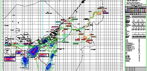
Creation of Integrated Pipeline Map

The Client is one of the biggest Oil producing Company in UAE. The Company for Onshore Oil Operations operates onshore and in shallow coastal water of the Emirate of Abu Dhabi, one of the seven members of the United Arab Emirates which was established on 2nd December 1971. The integrated pipeline map was created based on the source of inputs, type of inputs and the requirement gathered from the end user and the Client. VS engineering was involved in this project from Carrying out the Work shop to gather the requirements and to freeze the data model of the target GIS System. Plotting was also part of the scope. We know that the pipelines network originates from wellhead through the tough terrain terminating at refinery and/or sea port.

View shed Analysis and Land base creation

Client is the largest global player in smart metering with one of the broadest portfolios in the industry, its products, solutions and services empower utilities and consumers with the data necessary to make informed decisions about energy usage.In order to find the accurate location of installation of meters based on the geographical location, Client wanted to create a land base data where VS was asked to create or extract the land base features such as Road Edge, Road Centre Line, Building, Hydrology Features, Vegetation, Open Space Boundary mapping. Labeling Sector No, Road Name, Land Marks using satellite imagery. Attribute data like road name, locality name, building names etc was also extracted for the same data set.

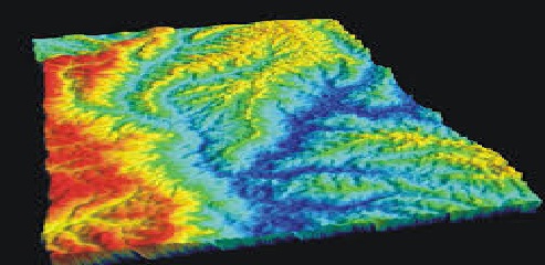
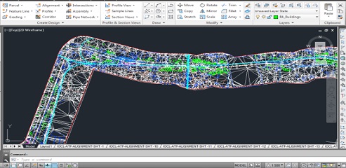
Creation of 2D Alignment sheets for Oil Pipeline (Pipeline Alignment Planning & Route visualization in 3D)

This project required survey of whole pipeline and creation of complete pipeline alignment based on the survey inputs. We also created a 3D visualization (Fly-through) for whole pipeline. The platform used for creation of alignment sheets was Autocad Civil 3d.

  • Creation of Template in AutoCAD for alignment sheets
  • Conversion of Survey inputs in AutoCAD
  • Creation of surface (DEM)

FTTX Planning & Designing

The telecommunications has matured to offer network convergence and enable the revolution of consumer media device interaction. The ageing copper access infrastructure in residential and business locations is unable to meet the demand of increase in bandwidth for several applications. These demands can only be met by the deeper penetration of optical fiber in Access network and increasing deployment of Fiber to the Home (FTTH). As a result FTTH is the fast growing global broadband technology with significant deployments World-Wide.

Software Development

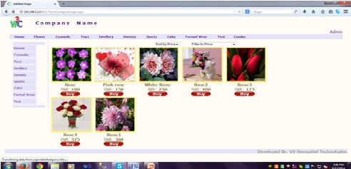
Online Shopping

The project is a web based dynamic application in which users could purchase their product and could also search product online. Only registered users could purchases their product. Admin have all the privileges regarding user information and each product watch-over. He could also edit or update or delete a particular entity. This project is developed under three-tier architecture.


ADDRESS

  • Address: O-8, A-5 Dilshad Garden,
    New Delhi 110095
  • Email:
    HR: hr@vsgeospatialtechnologies.com
    Sales: sales@vsgeospecialtechnologies.com
  • Website: http://vsgeospatialtechnologies.com/ Website: http://vsgeospatialtechnologies.in/
  • Phone No: +91-011-43044109

FLICKR GALLERY

  • 01 (6)
  • 01 (254)
  • 01 (196)
  • 01 (65)